Kawepūrongo
News
Making room for the river: how we got here
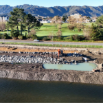
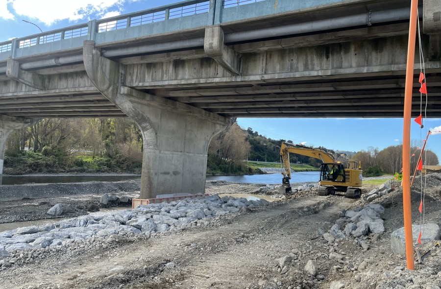
Updates, 22 June 2026If you’ve passed by Melling Link Bridge recently you may have noticed some activity going on underneath it. Our crews have been installing rock along the edge of the berm to help protect it from erosion. To keep the bridge safe during construction, the team protect the bridge pier with timber and use specialist technology on the digger to avoid hitting the bridge while placing the rock.
It might look like a small piece of maintenance, but it’s part of something much bigger and the thinking behind it has been shaped over decades.
Greater Wellington’s principal river engineer, Sharyn Westlake, explains: “For much of the 20th century, the approach to Te Awa Kairangi/Hutt River focused on control. Large-scale works completed in the 1970s straightened and narrowed the river channel, using hard engineering to hold the water in place and protect growing communities. This was the approach of the time: Lower Hutt was expanding rapidly, and those stopbanks were needed to prevent homes, businesses and infrastructure from flooding.
Over time, though, those choices created new challenges.
Narrowing the river and building close to its edge, particularly through the city centre, constricted the river, leaving no room for flooding and other natural processes. In some areas, flood protection levels ended up lower than what might be expected for a major urban centre, with certain sections historically designed to manage smaller flood events. As the city grew, so too did the consequences of that risk.
“At the same time, flood management was often reactive. Reviews in the 1990s highlighted that protection levels were inconsistent, and that the approach wasn’t keeping pace with population growth or the scale of the risk. It became clear that a different way of thinking was needed.”
From the early 2000s, that shift began to take shape.
Sharyn explains: “The Hutt River Floodplain Management Plan set a new direction, one that looked ahead, rather than simply responding to events as they occurred. It introduced a long-term programme of work, looked more holistically at river management and lifted expectations around the level of protection the river system should provide.”
Te Wai Takamori o Te Awa Kairangi, builds on that foundation.
Rather than continuing to force the river into a tight space, the focus has moved to giving it more room to function naturally. This includes widening parts of the river corridor, reshaping stopbanks, and making changes to surrounding infrastructure so that it works with the river, not against it.
“The work happening under Melling Link Bridge is one example of this shift. Rock protection, planting, and careful management of gravel all play a role in helping guide the river’s flow and reduce erosion, small but important pieces of a much larger system,” says Sharyn.
“This approach also reflects the reality that the risks we face today are different from those of the past. More people, more development, and the increasing impacts of climate change mean we need to think more carefully about how we live with the river over the long term.
Each stage of river management reflects the knowledge and priorities of its time. But as those priorities change, and as our understanding grows, so does our approach.
What we’re seeing now is the next step in that evolution.
Over the coming weeks, we’ll be sharing more about the work happening in and around Te Awa Kairangi/ Hutt River, from stopbanks and bridge upgrades to habitat restoration and bioengineering, and how each piece contributes to a safer and more resilient future for the city.
Tags
Recent Posts