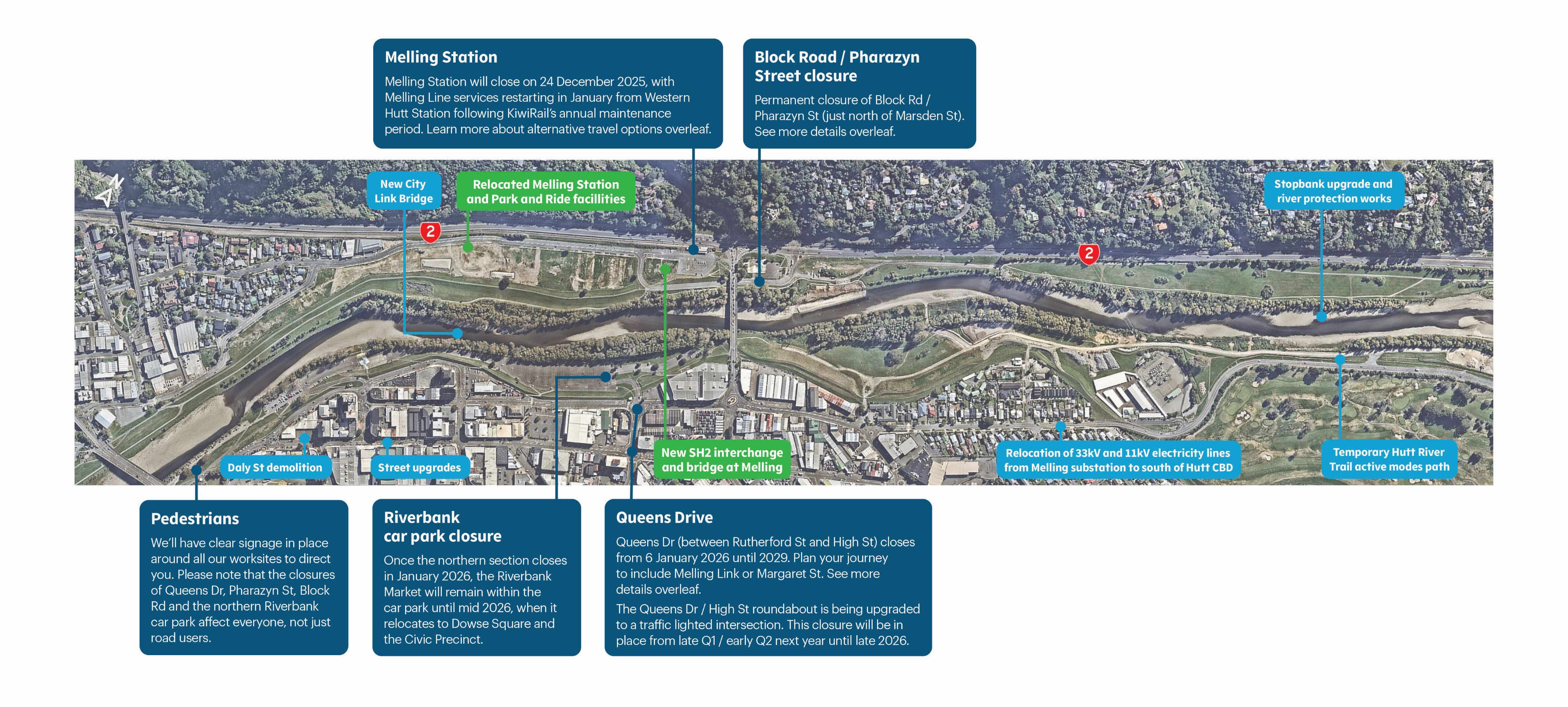
Closures and changes to local roads in 2026

Information on this page was last updated on 26 February 2026.
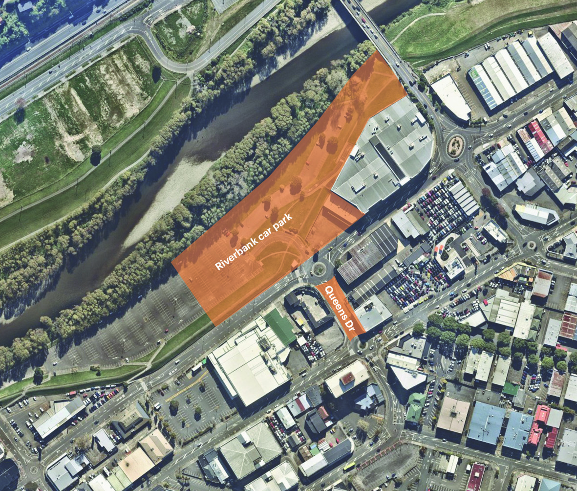
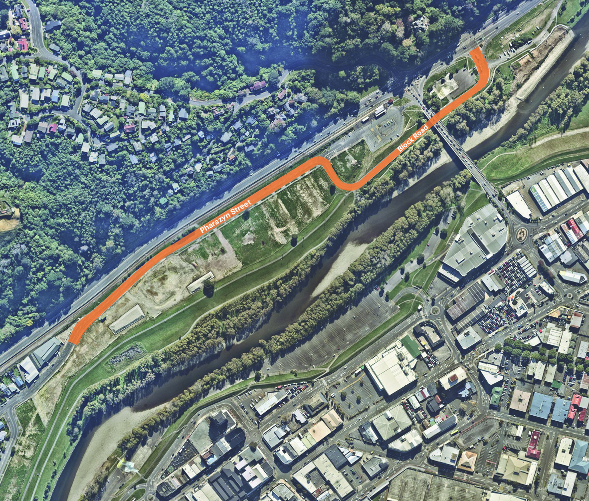
Queens Drive between Rutherford and High Street is now closed until approximately 2029. Block Road and Pharazyn Street north of Marsden Street and the northern section of the Riverbank car park are also now permanently closed.
We’ve provided some maps below so you can have a clear picture of the closed areas.
These closures will have a major effect on how people move around, and we appreciate they are big changes. Your journeys around these areas will be different, and in many cases will take longer and be less convenient.
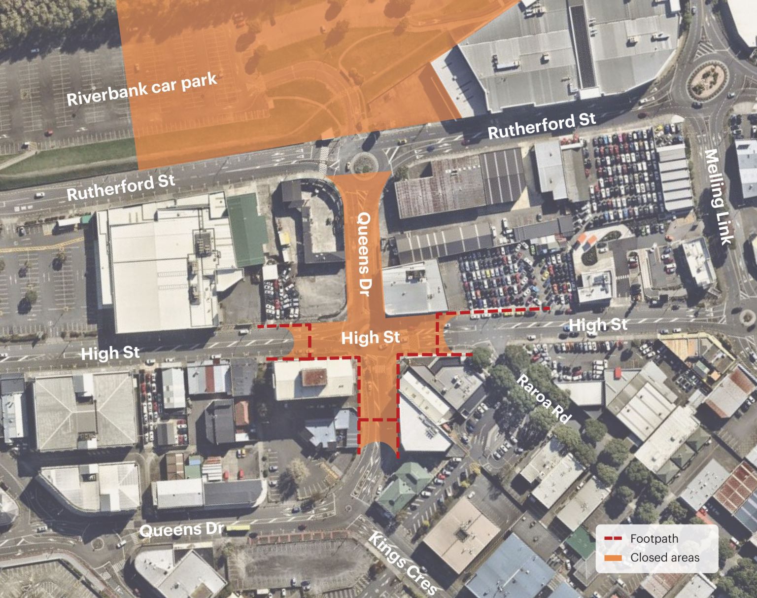
What’s happening on Queens Drive / High Street?
From 9pm Sunday 1 March – December 2026, the existing roundabout at Queens Dr/High St is being removed and replaced with a traffic lighted intersection. This will prepare the area for increased traffic volumes when Queens Dr connects the CBD to the new bridge over Te Awa Kairangi / Hutt River, as part of the SH2 Melling Transport Improvements project.
During the closure period, we will be relocating underground services like power, water, gas, and fibre; installing new drainage and stormwater systems; new footpaths, traffic islands, new signage and road markings to direct road users around the upgraded layout once we’ve replaced the existing roundabout with traffic lights.
The bus stops (#9117 and #8117) outside Burger King and Armstrong’s Nissan Lower Hutt on High St are being temporarily relocated to Cornwall St. Northbound buses will be re-routed from Queens Dr, right into Waterloo Rd, left into Cornwall St and then left into Pretoria St. Southbound buses will travel down Pretoria St, right on to Cornwall St, right on to Kings Cres, and then left back on to Queens Dr (retaining bus stop #8116).
Routes 110, 120, 145, 149, school bus 951, and N22 will detour via Cornwall Street for the duration of the works. More information and maps are available from Metlink here: https://www.metlink.org.nz/news-and-updates/detours-and-closures
This change is one of the most disruptive we’ll have to make during the construction of the SH2 Melling Transport Improvements project, and we’re acutely aware of not only the impact it’ll have on how people move around the area, but of the cumulative impact of all the work going on around the Melling area and CBD.
The only other way we could make the necessary changes to the intersection would involve 18 to 24 months of stop/go traffic management, weekend and night closures, and ultimately, a less safe environment for you to drive through and for our crews to work in. This closure will allow us to get far more work done in a much shorter period.
Once the project is finished, this new intersection, together with the upgraded Queens Drive – Rutherford Street intersection, will be the gateway to Lower Hutt from the SH2 Melling interchange.

What’s happening on Queens Drive?
Queens Drive is where the new bridge over Te Awa Kairangi / Hutt River will connect with the CBD. We need to close it so we can prepare the area for increased traffic volumes, including road and footpath widening, new drainage, underground service relocation, footpaths, lighting, surfacing and road marking. The roundabouts at Rutherford Street and High Street will be replaced by traffic lights.
We will also be making some layout changes to the section of Rutherford Street from approximately Woolworths to where it joins Melling Link. These won’t affect access, but the road will look different, and drivers will need to be aware of construction traffic.

What’s happening on Block Road and Pharazyn Street?
Block Road and the section of Pharazyn Street north of Marsden Street need to close so we can build the new Melling train station and facilities; relocate utilities and complete ground improvements, which are important first steps in the construction of the new SH2 interchange and bridge over Te Awa Kairangi/Hutt River. The interchange and bridge itself will be built right where Block Road meets Pharazyn Street.
Pharazyn Street will be realigned as part of the works on the western side of Te Awa Kairangi/Hutt River, and will connect with the new SH2 Melling interchange once that’s complete.

Path closure update
With Block Rd and a portion of Pharazyn St (from just north of Marsden St) closed, and the steel safety barriers due to be installed on the southbound shoulder of SH2 (500m north of the Block Rd/Tirohanga Rd intersection to Normandale Bridge) in March, the existing pedestrian crossing over SH2 from Tirohanga Rd to Block Rd is now closed.
Pedestrians/cyclists from Tirohanga Rd heading towards Lower Hutt need to use the existing crossing at the bottom of Harbour View Dr, followed by the existing crossing over SH2, before crossing the Melling Link Bridge to the eastern side of the river (or vice versa for the return journey). This is illustrated on the map below and signs have been installed on site.
Now that Queens Dr (between Rutherford St and High St) and the northern section of the Riverbank car park is closed, one of our initial tasks is to remove the roundabout island on Rutherford St. This work is complete.
At the same time, Wellington Electricity is relocating cables on Rutherford St, this work is estimated to be completed by late February 2026. Whilst these works are being undertaken, the shared path alongside the river will remain open between Melling Link Bridge and Ewen Bridge, with pedestrians also able to use the existing footpath on Rutherford St. This is illustrated on the map below and signs have been installed on site.

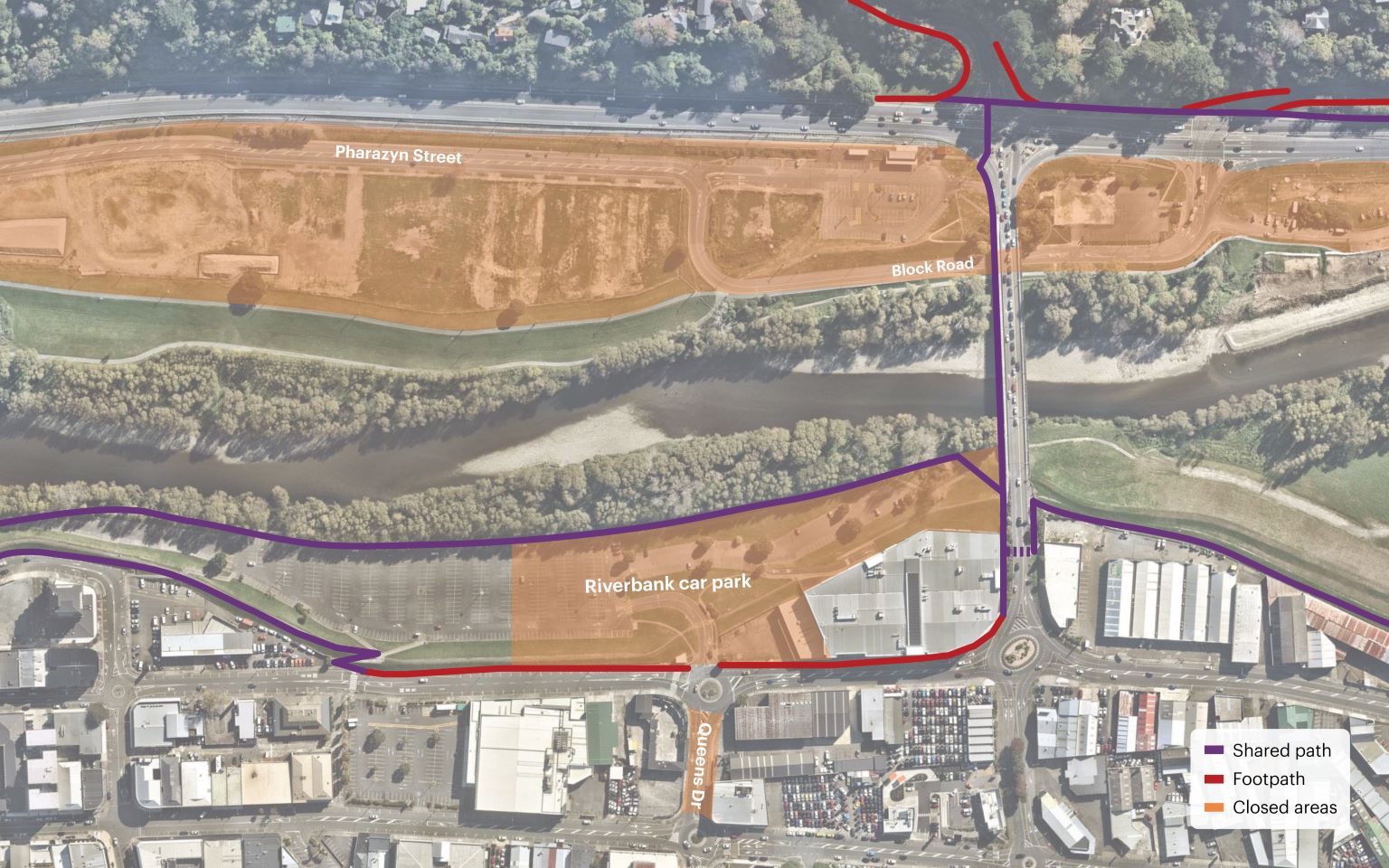
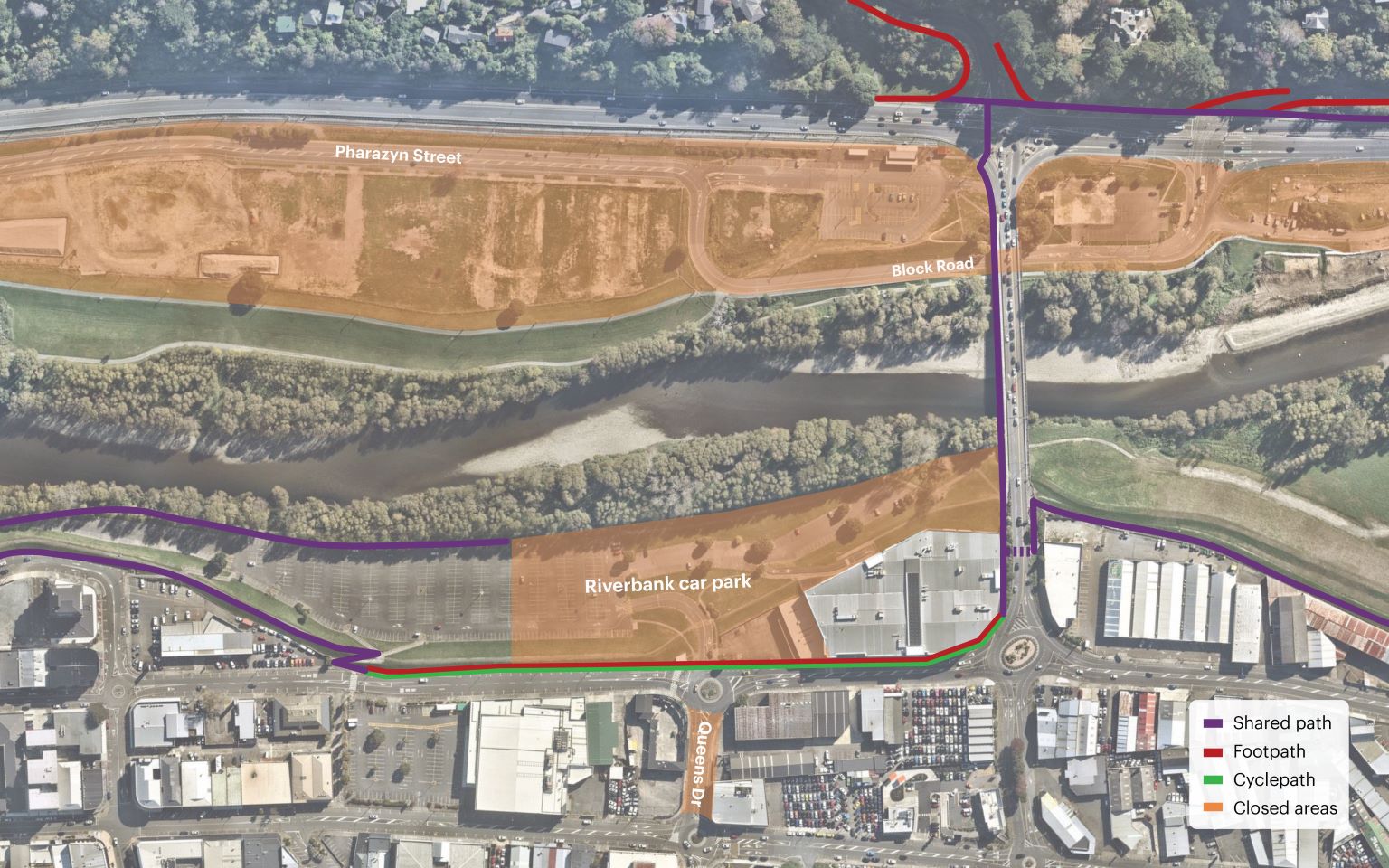
Once the roundabout on Rutherford St and the Wellington Electricity works are complete (estimate late February 2026), a temporary cycle path will be installed on the northbound lane on Rutherford St, from the existing pedestrian crossing (in line with the back of Woolworth’s car park), heading north past Harvey Norman, and connecting to the existing Melling Link Bridge. The shared path adjacent to the river will then terminate in line with the closed section of the Riverbank car park, as shown on the map below. Updated signage will be installed when this route changes, with updates shared on our Facebook, website and programme newsletter.

Changes on State Highway 2
Over the Christmas break, KiwiRail removed the rail tracks and overhead lines between Melling and Western Hutt stations.
From mid February the southbound lanes on SH2 will be re-marked with a new realigned lane layout, prior to installation of safety barriers.
The barriers (around 2km of temporary steel safety barriers in the left southbound shoulder of SH2, starting from approximately 500m north of the Block Road / Tirohanga Road intersection, and finishing at Normandale Bridge) will keep traffic and our crews safe while we scale up work on the off and on-ramps to support the new Melling interchange; the lanes will be slightly narrower and the speed limit through this area will be reduced to 70km/h.
Installing these barriers will make the shoulder much narrower and in some areas, will remove it altogether. Cyclists may wish to consider alternative routes.
We’ll need to keep this new layout in place for the majority of the construction period – through to around 2031.
What’s coming next?
The next big change will happen in March 2026, when we close the intersection of Queens Drive and High Street to remove the roundabout, install traffic lights, and prepare that intersection for the increased traffic volumes the new interchange will bring to that area. This work will be completed in late 2026.
We can’t build the bridge and interchange without these closures. They’ll allow us to work as quickly and efficiently as possible – giving us unrestricted access to the construction sites – and keeping both us and you safe while we work.
Now that the northern section of the Riverbank car park is closed, the Riverbank Market will move south, but remain in the Riverbank car park. They’ll then move to Dowse Square and the surrounding Civic Precinct in mid-2026.
You can find out more about the overall Te Wai Takamori o Te Awa Kairangi programme, including works being delivered by Hutt City Council and Greater Wellington, by clicking here. www.teawakairangi.co.nz/coordinated-construction-programme
FAQs
How can I get around the closed areas?
Queens Drive
Traffic needing to move between Rutherford Street and High Street will need to use Melling Link or Margaret Street.
Block Road / Pharazyn Street
Traffic wanting to enter or exit State Highway 2 will need to use either the Melling intersection or Dowse interchange. Traffic congestion is likely to be worst around Melling Bridge, so we recommend motorists use the Dowse interchange or go north on Harcourt Werry Drive and use Kennedy Good Bridge.
Access to Normandale and the area of Melling north of Railway Avenue will be via Hutt Road, Railway Avenue and Ewen Bridge.
Melling Station
Melling Station, its car park and the Park and Ride facility, including access to Pharazyn Street is now closed, with Melling Line services terminating at Western Hutt Station. Additional parking has been provided at Petone Station, or commuters can catch the Hutt Valley Line from Waterloo or Ava for the same price as a journey from Melling. Alternatively, buses #145 and #149 will take you to Waterloo Station for easy connection, or you can take the #83 bus from Queensgate direct into Wellington.
How will people on foot and on bikes move around the closed areas?
We have clear signage and safety messaging around the project areas to safely move people around our sites. Please be mindful of heavy vehicle movements and follow the direction of site staff and traffic management at all times.
I’m a cyclist - what happens to the shoulder?
Installing these barriers will make the shoulder much narrower and in some areas, will remove it altogether, so riders may wish to consider alternative routes.
Why are these changes needed?
North of Melling, we’ll be starting construction on the southbound offramp for the new Melling interchange, which will run right alongside the current highway. We’ll remove the existing steel barrier and vegetation, before preparing the ground and beginning to raise it to align with the level of the current highway.
South of Melling, the railway line, ballast rock and overhead infrastructure will be removed, and we’ll start preparing the area for construction of the southbound onramp, which, as with the offramp, will run right alongside the existing traffic lanes. We’ll also start preparations for the new Melling Station platform and park and ride facilities.
How long will these changes be in place for?
We’ll need to keep this new layout in place for the majority of the construction period – through to around 2031. However, we’ll need to make other changes to the area as we move through the construction programme over the next few years. We’ll communicate these in advance, but as with all construction sites, timeframes can change quickly, so the best way to stay informed is to follow our Facebook page, where we’ll post regular updates.