
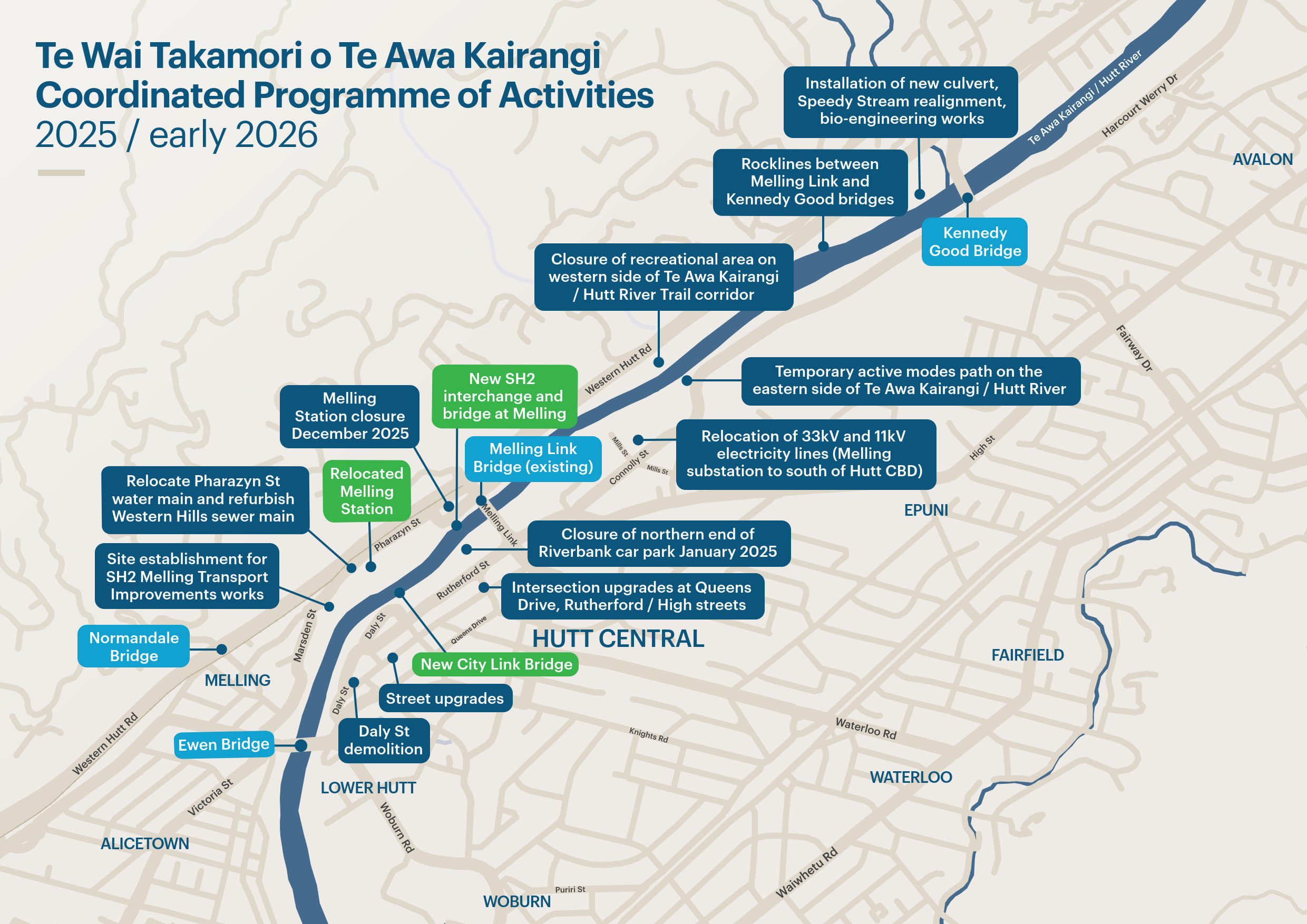
Coordinated construction programme
This page provides an overview of coordinated construction activities scheduled to begin between now and the end of 2025.
This includes work being completed by Greater Wellington, Hutt City Council and NZ Transport Agency Waka Kotahi as part of Te Wai Takamori o Te Awa Kairangi.
There will be significant changes in Lower Hutt over the coming years as a large programme of construction begins on both sides of Te Awa Kairangi / Hutt River. This construction will have an impact on how people move around the city, and it will vary over time as construction starts and finishes in different areas.
The table and map below highlight what work is happening in the next 6-8 months, where it is, who is carrying out the work and the disruption you’re likely to experience.
We’re committed to minimising the impact of construction across all parts of Te Wai Takamori o Te Awa Kairangi. But it’s important to remember that large infrastructure projects, such as this, are complex and disruption will be inevitable. While these disruptions will be inconvenient at times, this project will bring long-term benefits to the community.
Over the coming months, we’ll continue to update this page as activities and timeframes are confirmed – this includes work happening in 2026 and beyond.
Last updated: Wednesday 2 October 2025
|
When |
Where |
What's happening |
What this means for you |
Who is doing the work |
|
Already happening and is ongoing |
Various sites around the city and river |
Small scale site investigation works, e.g. drilling new boreholes for ground water monitoring |
Occasional, minor changes to access or parking – typically only for a few hours. |
Te Awa Kairangi Alliance |
|
Already happening and is ongoing |
On both sides of Te Awa Kairangi / Hutt River between Melling and Kennedy Good bridges |
Rocklines being built to strengthen the river’s edge |
Some small sections of the Hutt River Trail by Block Road may be diverted. Heavy machinery working in the river and on the river’s edge. |
Greater Wellington |
|
Already happening and is ongoing |
Marsden Street |
Underground demolition |
Heavy machinery at site Monday-Saturday. Some noise and possible vibration. No change to traffic routes. |
Greater Wellington |
|
Already happening and is ongoing |
Land behind Belmont School |
Work near Belmont School, including: - Installing a new culvert near the car park area to improve drainage - realigning Speedy stream and creating a small beach area - lowering the current height of the grassy area to new design levels |
Heavy machinery will be in place during the day – Monday to Saturday. Minor disruption for a couple of days to the existing walking track just south of the car park. |
Greater Wellington |
|
August 2025 |
At the river’s edge below Belmont School |
Bio-engineering works |
Heavy machinery will be in place during the day – Monday to Saturday. Minor changes to public access to that part of the river’s edge while work is underway. |
Greater Wellington |
|
From September 2025 and ongoing |
Western side of Te Awa Kairangi / Hutt River near Melling |
Site establishment for SH2 and Melling Interchange including: - fences and hoardings go up around site perimeter - material and plant machinery deliveries begin - portacabins and storage areas established - preloading of ground using piles of material |
Minimal disruption, limited to site areas only.
|
Te Awa Kairangi Alliance |
|
From mid October 2025 to December 2025 |
Pharazyn St and Block Road
|
Pharazyn St water main relocation and Western Hills main sewer lining
|
Expect stop/go traffic management on Pharazyn St and Block Road. Closure of 4-6 car parks in the Melling Park & Ride area for approximately a week. Closure of car parks on Block Road. |
Te Awa Kairangi Alliance |
|
From mid October 2025 |
River corridor area between Block Rd and approx. 800m south of Belmont School |
Closure of western side of Te Awa Kairangi / Hutt River corridor for site establishment for Melling Link Bridge and SH2 works |
All users including walkers and cyclists will need to use a temporary path on the eastern side of Te Awa Kairangi / Hutt River. |
Te Awa Kairangi Alliance
|
|
From mid October 2025 |
River corridor area approx. 500m south of Melling Link Bridge |
Closure of western side of Te Awa Kairangi / Hutt River corridor for site establishment for Melling Link Bridge and SH2 works |
Path users will be diverted to nearby street footpaths (Pharazyn St, Marsden St and Block Road), or the eastern side of Te Awa Kairangi / Hutt River. |
Te Awa Kairangi Alliance
|
|
From mid October to early December 2025 |
Exact locations TBC |
Installation of ground water monitoring equipment |
Minimal disruption, limited to site areas only. |
Te Awa Kairangi Alliance |
|
From November 2025 |
Rutherford St / Queens Dr area |
Site establishment |
Minimal disruption, limited to site areas only. |
Te Awa Kairangi Alliance |
|
From November 2025 |
Starting at Melling Substation, heading south to Connolly Street and Melling Link |
Relocation of 33kV & 11kV electricity lines begins |
Expect traffic management and restricted access to the riverbank and shared path areas. |
Wellington Electricity Lines Limited (Greater Wellington) |
|
From November / December 2025 |
Daly St |
Possible asbestos removal and demolition |
Investigations and works that are largely inside private properties. From January 2026, Daly St between High St and Andrews Ave expect traffic management and restricted access. |
Greater Wellington |
|
From December 2025 |
Beneath Melling Bridge on the eastern side of Te Awa Kairangi / Hutt River (exact location TBC) |
Rocklines being built in Te Awa Kairangi / Hutt River under the bridge |
Expect restricted access to the riverbank and shared path areas. |
Greater Wellington |
|
From 24 December 2025
|
Melling Station and line between Melling Station and Normandale Bridge
|
Melling Station closes. Melling Line services will terminate at Western Hutt Station from 12 January 2026. Work begins to remove overhead lines and railway infrastructure. |
People who usually travel to/from Melling Station will need to make alternative travel plans for the new year. More bike parks will be provided at Waterloo and Petone Stations. Additional Park & Ride facilities will be provided at Petone Station from December 2025. Choose the route that works for you and stay up-to-date with options at: www.metlink.org.nz/mellingstation |
Metlink / Greater Wellington / Te Awa Kairangi Alliance |

Stay in touch
Te Wai Takamori o Te Awa Kairangi is a transformational project for Te Awa Kairangi ki Tai - Lower Hutt. It includes crucial flood protection and river restoration work, improvements to public transport, walking & cycling routes, local roads and the SH2 Melling Interchange, as well as urban revitalisation of the Lower Hutt city centre and a new pedestrian bridge over the river.
Follow us on Facebook and subscribe to our regular eNewsletter for programme updates, changes to construction timing (e.g., if weather dependent) and other news.